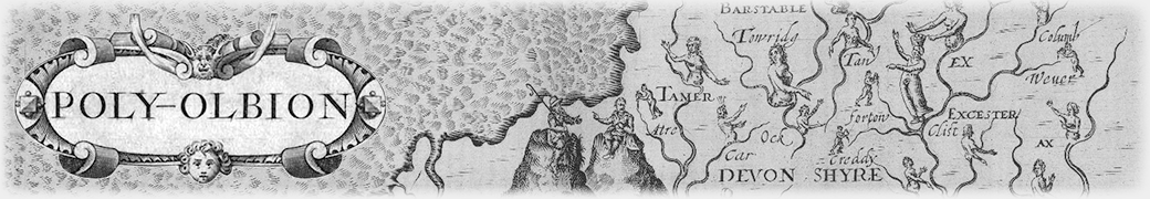
The distinctive county maps of Poly-Olbion were produced by the engraver William Hole. He was working early in the era of British cartography: William Saxton’s Atlas of England and Wales was published in 1579; John Speed’s Theatre of the Empire of Great Britaine was published in 1611. Hole is endebted to such predecessors, but aims less for factual accuracy than for an engagement with the spirit of Drayton’s poem. His maps capture the poem’s anthropomorphizing of the land and its engagement with historical myths. They are—again, like the poem—quite light on the kind of cartographical detail that was driving Saxton, Speed and their peers.
The maps also follow the poem in their organization. There is not a single map for each county; rather, there is a map for each song, and the songs often combine counties. As a result, there is no attempt to present them to a common scale. While some existing copies of the maps (as of Saxton’s and Speed’s) are gorgeously coloured, this was not done at the time of printing; colouring was done case-by-case, often a long time after publication. We discuss Hole’s penmanship and his work on another landmark Jacobean book, Coryats Crudities, in tumblr posts.
Other Illustrations
William Hole produced other illustrations for Poly-Olbion, including a striking illustration of Prince Henry (Drayton’s intended patron, who died in the year of the book’s publication)–see the figure on the left of this page. The most stunning image of all is the frontispiece, which we discuss in a tumblr post.
![Prince Henry at the pike, by William Hole, from Poly-Olbion. Image from Folger Shakespeare Library [http://luna.folger.edu/luna/servlet/s/7g0wry].](http://poly-olbion.exeter.ac.uk/wp-content/uploads/2015/11/012944.jpg)
Prince Henry at the pike, by William Hole, from Poly-Olbion. Image from Folger Shakespeare Library [http://luna.folger.edu/luna/servlet/s/7g0wry].